
Moab, Utah
We Are please to announce the Launch of the Moab, UT field guide. A dozen routes, stories and art at your fingertips so you can reimagine the epic destination of Moab from a Gravel point-of-view.
Introduction
A rugged landscape composed of sandstone fins, arches, balanced rocks, and desert silence is what makes the former mining town of Moab a purely unique gravel-adventure experience. Despite its global offroad-cycling popularity, the surrounding terrain remains vast, serene, and ever capable of providing inspiration for the adventure traveler in all of us. Gravel riding in Moab reminds us that cycling still delivers an authentic encounter with the wilderness.
By itself, Moab has played an important role in elevating and promoting offroad-bike destinations on a global scale. The discovery of Moab by cyclists in the late 1980s and early ‘90s helped turn mountain biking into a bona fide sport; in turn, this gravel guidebook draws inspiration from that era’s culture-making impact on Moab.
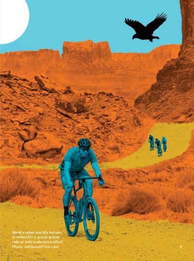
Gravel bikes are the perfect way to uncover the magic of the red-rock canyon country. Adventure travel on rough overland and double-track roads on drop-bar bikes, influenced by mountain-bike-equipment design, lets you engage in a meditative way with the desert landscape—gravel bikes help us humans connect with the natural world. Moab might be the most incredible place on Earth. And, fortunately, it’s also an incredible place to ride a gravel bike.
Welcome
Moab, Utah, has been a hub for mountain bikers and offroaders for decades. Now, we’re inviting gravel bikers to explore its thousands of miles of trails and roads. This isn’t your average gravel experience—expect overland gravel roads with grit, amazing views, and a long history of exploration. You’ll want to run 47mm-50mm or 2.1+ wide tires on your bike—but what about Moab is ever average, anyway?
This edition of the Gravel Adventure Field Guide encourages adventure cyclists of all skill levels to explore the layers of Moab, mile by mile. This isn’t a destination that can be covered in a day—it can hardly be covered in a lifetime. Gravel bikes provide the magic ingredient for going deeper: for finding new trails, new roads, new viewpoints, and new ways to connect the landscape. Take time to visit the many shops, galleries, and the museum to deepen your knowledge of Moab. This guidebook highlights why this place is so special to the people who travel here year after year, and to those who stay for a lifetime.
Road Origins

Many of the routes you’ll explore on your Moab gravel adventures have been used for thousands of years. In a region made up of deep canyons and vast vistas, the Moab valley provides the only major crossing of the Colorado River for miles.
According to the National Park Service, nomadic Indigenous groups began settling in the Four Corners region roughly 2,000 years ago. These early agriculturalists, known as the ancestral Puebloans, left the region about 700 years ago. They were followed by the nomadic Shoshonean peoples, including the Ute and Paiute, who carved their stories into petroglyph panels and were in the area when the first European settlers arrived. Countless tribes migrated through and settled in this area; today, we consider these lands the homelands of tribes including the Ute, Navajo, Paiute, and Hopi.
Moab grew slowly through the early 1900s: The journey to Moab was arduous, and required patience. Rough double-track and primitive wagon roads, including roads used along the Old Spanish Trail, extended through Moab; the journey often required a ferry ride across the Colorado River. Moab became more accessible to travelers after the first bridge over the river was constructed, in 1912. Roads throughout the region were mainly used to transport cattle.
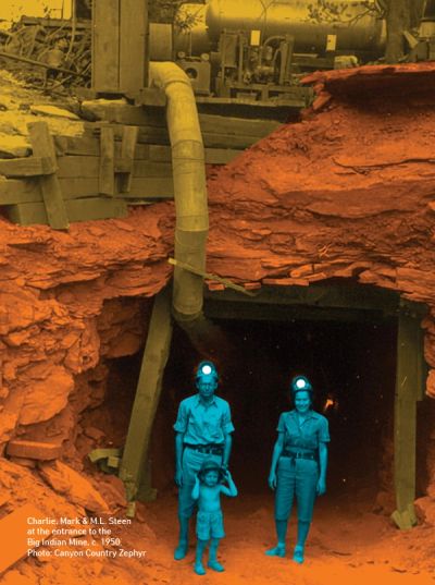
In 1952, the geologist Charlie Steen discovered one of the country’s richest uranium deposits just outside Moab, creating a uranium “boom.” The town’s population grew 400 percent, and Moab crowned itself the richest town in the USA. As thousands of mining claims were staked across public lands in Grand County, prospectors needed vehicle access for their mining operations—so the Atomic Energy Commission expanded upon and built thousands of miles of gravel roads, creating better accessibility throughout the region for miners and visitors both.
By 1970, the uranium-mining industry was in significant decline—government contracts to buy uranium had only lasted until 1966. Just two years prior, in 1964, Canyonlands National Park had been established just outside Moab. Arches was a burgeoning national monument (established 1929), and Dead Horse Point State Park (established 1959) was quickly becoming a favorite camping spot. The town of Moab looked to tourism as a viable economic path: In 1965, Canyonlands reported 19,400 visits, while Arches reported 143,900. Tourists and locals alike were finding that they could explore mining roads outside the parks in their vehicles—the first “Easter Jeep Safari” took place in 1967.
Today, you can recreate on those same roads, using much of the same infrastructure created by the cattle industry, mining machines, and 1960s vehicle tourism.
Community
Grand County has a population of 9,700 residents in 3,700 square miles. Its largest municipality is Moab, Utah (population 5,200), a gateway town to two national parks (Arches and Canyonlands), two state parks (Dead Horse Point and Utahraptor), over 3 million acres of public lands, and the Colorado River. The area sees an estimated 2.5 million visitors annually.
The stories here go far—beyond just Delicate Arch. This slice of Utah is a geologic wonder: The rich and colorful layers of sedimentary rock you see today were deposited over millions of years; so too were the nearby canyons, fins, and arches carved by wind, water, and freeze-thaw cycles. These extraordinary landscapes have left visitors and locals alike mesmerized for millennia.
Today, Moab remains a small town with a big spirit, and everyone dines at the same table. When you go for that post-ride milkshake at Milt’s, you’ll be in line with guides, artists, scientists, offroaders, climbers, cowboys, hikers, bikers—and often folks who are some combination of all of these. xxx

Four Season Gravel
Moab is a dynamic desert landscape, which makes it an ideal four-season gravel-bike destination. Winter brings quiet solitude on red-rock-lined dirt roads, while spring conjures a desert awakening of wildflowers and wildlife migration. Summer is the best time to view the Milky Way, and fall days are filled with perfect temperatures and golden desert light. Moab reveals a new personality every season—especially when seen from a bike.
Winter is best for your long rides, especially rides that overlap with pavement. While there isn’t as much daylight as in other seasons, Moab rarely sees temps cold enough to sabotage your adventure—and if the sun is shining, you’ll want a lighter layer to peel down to under your jacket. Fewer visitors also means quieter trails to yourself.
Spring is a popular season to be in Moab. Temps are gorgeous, the cacti are blooming, and local birds—including fearsome birds of prey—begin building their nests. During this season, you’ll want to break out your bikepacking gear to extend your time in the saddle and sleep under the stars.
In summer, plan to ride early in the day, so you can hop in your hotel pool (or take a guided river trip) in the afternoon. At night, enjoy the best views of the Milky Way all year. No sugarcoating the fact that summer in Moab is hot: It’s a desert, after all. June sees temps in the 90s, and in July and August, temperatures regularly spike above 100.
Fall is the golden desert season, bringing many visitors to Moab—for good reason. The cottonwoods along the Colorado River turn bright yellow, along with the aspens in the La Sal Mountains. This is a popular season to join a local bike event, including Outerbike, the Moab Ho Down Mountain Bike Festival, and the Skinny Tire Fall Festival. Plan a longer stay when you come in the fall, to leave room for more exploration.
Sustainable Gravel

Safety & Desert Conservation on the Colorado Plateau
Moab is one of the most sought-after adventure-travel destinations in the Southwest. This notoriety and popularity mean that all visitors must be diligent in matters of planning, preparation, and stewardship, including visiting gravel cyclists, who are encouraged to be aware and intentional with their time in the desert backcountry. The landscape is vast and rugged, and the weather is often variable.
Planning and Preparation
Preparation for a desert gravel adventure is essential. Planning minimizes encountering scenarios that require emergency assistance. Here are some things you can do:
Be prepared for temperature extremes. Have appropriate clothing layers. In winter, take insulating clothing for any unforeseen circumstances encountered during a ride. In summer, a lightweight long-sleeved shirt and cycling cap can help you stay cool. Carry sunglasses and sunscreen.
Carry lots of water. You can never have enough water in the desert. Bring as much as your bicycle can accommodate. A gallon per person a day is a good rule to follow. Electrolyte replacement is essential—use powdered or liquid electrolytes, or something salty.
Bring food—a great gravel adventure requires energy. Eating adequate food helps maintain energy levels throughout the ride. Salty food choices are good ones.
Share your gravel-ride plans with someone. Let them know how far and long you plan to ride, and when you expect to be back. Never deviate from the plan without informing them.
Know your gravel route. Research and download your planned route to your phone or head unit. Save them for offline use. Cell phone and/or GPS coverage vary across the desert. Carry this Moab Gravel Adventure Field Guide and a compass as backup. If you do become lost or disoriented, contact rescue services and stay where you are.
Know your fitness and skill levels. In the desert, rides of a certain distance can take longer than typical gravel rides. Even expert gravel cyclists will find Moab’s terrain challenging and unforgiving. Be honest in assessing your fitness and skill levels. Take a light. It never hurts to carry a headlamp or flashlight—and extra batteries—on a Moab gravel adventure. Do not attempt to ride at night without illumination: The consequences could be deadly.
Take a cell phone. Regardless of inconsistent cell service in the desert, cell phones have assisted Grand County Search and Rescue to save numerous lives. Leave with a fully charged phone, and then leave it off, or in airplane mode, unless necessary. If calling 911, your location is automatically located. Cell-phone signals work better on mesa tops versus down in the canyons.
Carry first aid and supplies. Bicycle accidents happen. Be prepared with a basic first-aid kit containing adhesive bandages in assorted sizes, antibiotic ointment, rolled gauze, medical tape, and the means to cleanse a wound. Shears, tweezers, pain relievers (ibuprofen/acetaminophen) can also be helpful.
Know the weather and the forecast before you ride. Pay attention to the day’s weather patterns. In summer months, ride during the cooler hours earlier or later in the day. Be mindful of lightning and thunder, especially during monsoon season (July through September). Avoid slot canyons and drainages during threats of thunderstorms. If you hear thunder, lightning is close enough to strike.
Ride with the right equipment. Surface conditions on Moab’s gravel and dirt roads can vary. Gravel rides here can include chunky gravel, loose rocks, slickrock, and sand. Overland and/or double-track jeep roads require comfort with the rugged offroad-riding experience. Tire size is important: We recommend 47mm / 2.1” or wider tires, with sealant. Use bike bags, on handlebars or frames, to carry ride supplies.
Know the local camping regulations. Only the developed campgrounds within 20 miles of Moab allow camping. Dispersed camping is allowed on select BLM lands outside Moab. This link will provide more details if you plan to sleep under the stars:
discovermoab.com/stay/campgrounds
Stewardship
Please help protect Moab’s natural wonders for generations to come. The small actions of each gravel cyclist make a difference. Be mindful within your travel plans, seeking ways to minimize your impact while maximizing your experience. Visit and ride with respect, and take care of one another and our public lands.
Stay on the road or trail. Doing so is crucial to preserving them and protecting the fragile soil that sustains the desert ecosystem. Cryptobiotic soil, also known as biological soil crust, is foundational to healthy desert plant life. This unique black, knobby crust is composed of diverse living organisms vital to maintaining the delicate balance of the desert environment.
Though it’s incredibly beautiful and enticing, this soil crust is also exceptionally delicate and takes decades to regenerate. Even a single tire track, or footstep, can cause irreparable damage that can persist for years, reverberating into the entire ecosystem. We urge cyclists to stay on designated roads, routes, and trails, to ensure preservation of the soil crust. Learn more by visiting: discovermoab.com/plan/stewardship
The Number 2 Rule
Follow proper protocols for the disposal of human waste. Digging a cathole to poop in is illegal in Grand County, UT. In the desert, human waste doesn’t break down as easily or quickly—it produces health hazards. Use a developed toilet facility or pack it out in approved waste bags. These bags are referred to as “Waste Alleviation and Gelling Bags,” or WAG Bags—a double-walled, self-closing human-waste containers complete with crystals or gels to neutralize any dangerous pathogens. They must be disposed of at an approved WAG Bag disposal bin after use. Several locations, sell WAG bags. For more information and a list of locations visit:
discovermoab.com/plan/be-prepared/poop
Geology, Paleontology, and Petroglyphs
History of the Earth, and Ancient Human Expression
The Moab landscape is defined by the impressive geology of the Colorado Plateau. It is composed of Mesozoic sandstones, deep canyons, and distinctive salt-cored anticlines, of which is exemplified by Arches National Park. Shaping it all were ancient seas, sand dunes, and salt diapirism—the process whereby buoyant salt rose over denser overlying rock layers due to tectonic pressure to form structures such as domes, walls, and plumes. Sand Flats Road is a great place to see these large sandstone-dome formations.
Coinciding with geological processes of the Mesozoic Era was the active presence of dinosaurs. Common fossils found in Grand County include carnivorous theropods and giant sauropods, along with reptiles and amphibians. A notable discovery near Moab at Stikes Quarry uncovered the largest Utahraptor, (approximately 20 feet long) found within a 9-ton megablock of sandstone.
Rock-art sites of national significance can also be found within Grand County. The rock wall on Potash Road is a great example. Petroglyphs from the Formative Period can be seen from the roadside. The panel extends along the road 125 feet near the turn off for Longbow Arch. Look for the line of “paper-doll cutouts” and horned anthropomorphic figures holding shields, as well as a wide variety of other animals and abstract images.
It’s essential to preserve these incredible cultural works of art. It is best to observe the art from a distance and to not touch the petroglyphs. Simply take photos of these ares— these sites are sacred, and protected by law.
Adding a special layer to any Moab gravel-adventure outing:
Colorado River
Desert Specialists
Desert Specialists

Sitting below 4,000 feet, the river acts as a biological corridor in the desert, offering precious water and a canopy habitat. It behaves like a desert oasis flyway that bottlenecks in Grand County. This in turn supports high-density breeding zones for riparian migrants and songbirds.
Desert Specialists
Desert Specialists
Desert Specialists
Sitting between 4,000 and 5,500 feet, Grand County hosts a number of true Colorado Plateau desert species native to this geologically unique landscape. While riding your bike, pay attention to dramatic natural features such as arches, fins, and canyon walls where these birds dwell and deliver their dynamic songs.
Island in the Sky: La Sal Mountains
Island in the Sky: La Sal Mountains
Island in the Sky: La Sal Mountains
Rising 12,000+ feet above the arid landscape are the isolated La Sal Mountains, which create a unique “sky island” ecosystem in the desert. This produces a completely different bird community within 25 miles of Moab. Pedaling Sand Flats Road, for example, may result in witnessing the transition from desert wrens to alpine songbirds. Cooler temps make this zone an ideal spot for a summer gravel adventure.
Raptors and Cliff Ecology
Island in the Sky: La Sal Mountains
Island in the Sky: La Sal Mountains
The canyons of Grand County are ideal raptor habitat, with a combination of low human density and thermal updrafts that support soaring birds. Vertical cliff walls are where nests will be found. There may be no better way in the United States to observe raptor flight behavior than by taking a gravel bike ride though the canyon country of Grand County.
Gravel Birding
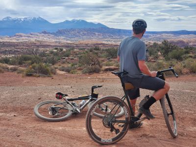
Grand County’s extensive road network on public lands—and access to riparian corridors and mesas—makes it a unique gravel-birding destination. It’s a low-density birding opportunity with high-quality experiences, made all the more special by being paired with a gravel ride. It’s rare nationally to be in a place where you can ride 40 miles, cross three ecosystems, and log 60 species along the way.
Seasonally Dynamic
Despite the stillness and solitude of canyonlands country, the desert teems with life. Bird activity in Grand County is never static: Spring initiates peak migration along the Colorado River corridor, and, in summer, desert specialists breed and montane species split. Meanwhile, fall brings secondary migration along the river and raptor action. Winter is sparser, but eagles, juncos, and other hardy residents make their presence known. Seasonal rhythms are what make Grand County an ideal gravel-birding destination, and repeat visitation will reward you with the chance to see a great variety of avian species.
Moab Art & Culture
The natural beauty of Moab serves to inspire the creative mind. The landscape attracts artists and art lovers alike to experiment with landscape painting, photography, and jank art (sculptures made from desert finds). Between the red rocks, Colorado River, and outdoor lifestyle, it’s hard not to think creatively while in Moab on a gravel adventure.
Downtown Moab hosts a number of galleries and boutique shops that compliment public art. Around Moab, you’ll find sculptures, murals, and community art gardens. To further engage with local art in Moab, attend an Art Walk or the Arts & Ag event spring through fall to meet artists, or plan your trip around the Red Rock Arts Festival.
To find more information about arts programming visit: www.moabarts.org.
Colorado Plateau at Night
Desert-Destination Darkness: Hosting the Greatest Number of accredited International Dark-Sky Places
Utah currently has the greatest number of certified international dark-sky parks anywhere in the world, and all three of them (Arches National Park, Canyonlands National Park, Dead Horse State Park) are located in the Moab area. Conservation focused on night-sky preservation is keeping the sky above the Colorado Plateau one of the darkest remaining areas in the contiguous United States. Overland rides, with epic views of unique rock formations and stunning vistas during the day, set the stage to see a cornucopia of stars at night, including the Milky Way. Under the right conditions, binoculars can be used to see the rings of Saturn.
Many of the petroglyph sites created by ancient people in the area surrounding Moab frequently feature astrological significance, with petroglyphs and pictographs marking celestial events like solstices and equinoxes. These artistic creations illuminate the deep knowledge of the Ancestral Puebloan, Fremont, and older cultures, and traditions that link shamanistic figures with the cosmos. Common depictions including spirals, circles, and sheep figures are thought to represent solar calendars, the movement of the sun, and other happenings.